Improving Air Quality – changes to the road network
This consultation has now closed. Thank you to everyone who responded to this consultation in November and December. The responses we received have been captured in a Consultation Report, which is available to download in the documents section on the right-hand side of this page.
We have considered all the comments received and the key themes have been summarised in the key themes document also in the documents section on the right-hand side of the page, this document also includes our response to these themes.
We are now reviewing the detail of the scheme designs following the comments we received, but some preparatory work needs to take place so you may see some activity at the sites. The Government’s legal direction for the Council to implement the Plan still applies, however, and any substantive changes to the package will require Government approval before they could be applied.
Air pollution is having a harmful impact on the health of people living, working and studying in Coventry.
Like many towns and cities throughout the UK, roadside pollution levels, especially those resulting from Nitrogen Dioxide (NO2) emissions from traffic, are a concern. We have been told by Government to reduce NO2 levels, especially on Holyhead Road where the levels are the highest in the city. If we cannot improve air quality the government will force us to introduce a clean air charging zone, which means you might have to pay to drive in some areas of the city.
The Council developed a Local Air Quality Action Plan which following consultation in 2019 and 2020. To develop the plan, around fifty individual measures have been assessed using traffic and air quality models. The package of measures outlined here is the one that best deals with the NO2 on Holyhead Road without transferring the problem to other areas in the city.
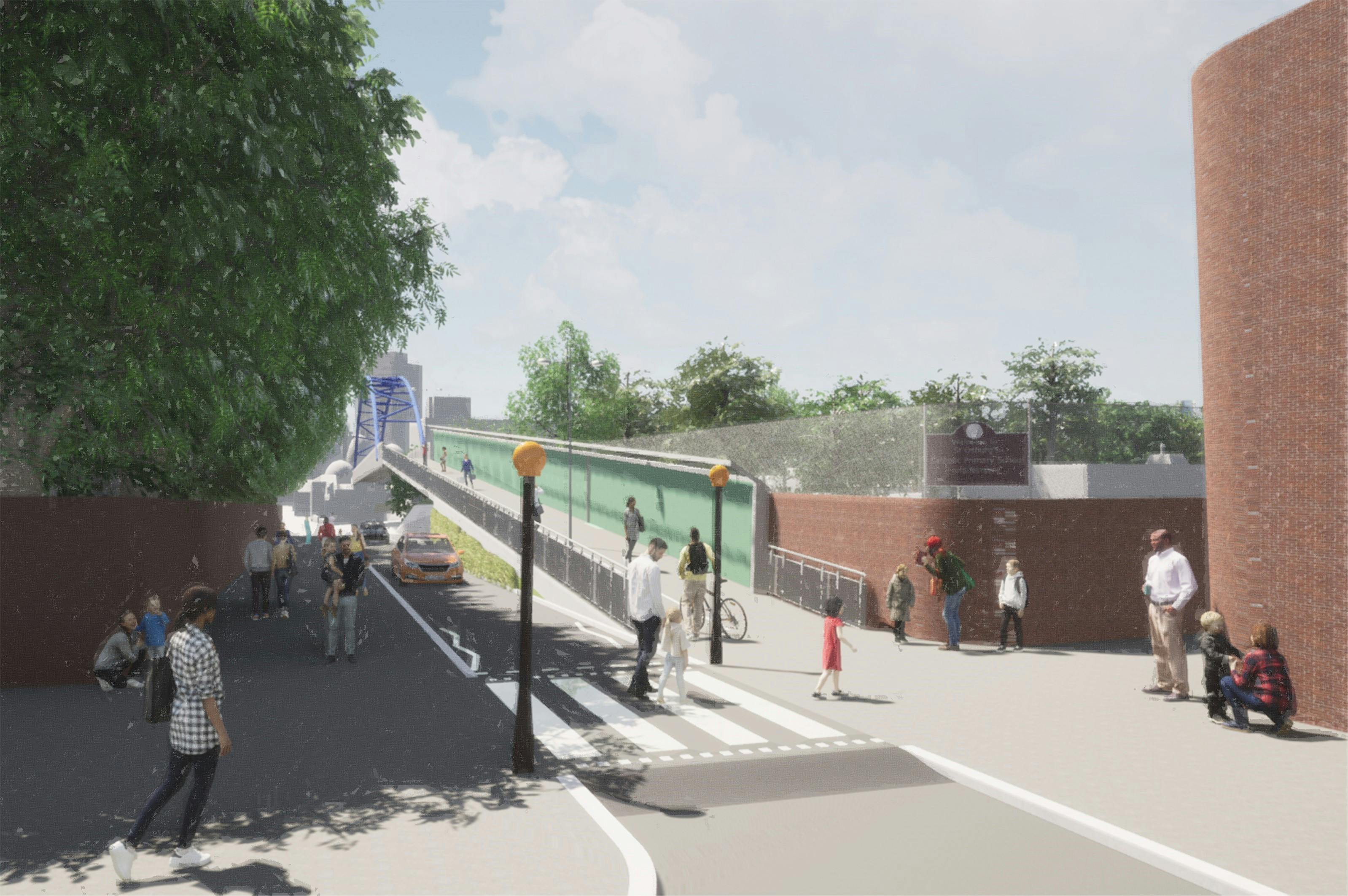
The plan includes work to reduce traffic on Holyhead Road and to direct traffic through a widened Spon End. To do this we will make changes to three areas around Holyhead Road. You can see the detailed plans in the documents section along with the Street News which was delivered to around 6,000 properties, on the right hand side of this page. You can also see how the schemes might look in the images section.
Spon End
To remove the pinch point which causes congestion at Spon End and to reduce traffic delays and queuing we will:
- widen from the former Black Horse and through the railway arches to Godiva Carpets to remove a pinch point. The Black Horse is locally listed but since it was listed, major alterations have been carried out which have changed the inside of the building. Demolition will be subject to planning approval
- widen the footpath outside properties on Spon End providing opportunities for planters and environmental improvements
- provide alternative parking for residents and businesses within the site of the current Godiva Carpets, where existing limited on-street parking needs to be removed
- widen from Upper Spon Street to Windsor Street to provide two lanes towards the city and provide space for shared cycleway and footpath
- provide a shared cycleway and footpath and link the cycleway to Upper Spon Street and Meadow Street to the city centre
- upgrade pedestrian crossings to toucan crossings to provide a safer cycle link to Junction 7
- upgrade traffic signals to facilitate dynamic traffic management, this means we can change the signal timings to respond to changes in the traffic flows
Ring Road Junction 7
To remodel Junction 7 including removing the roundabout and Moat Street car park and replace with a direct route from Spon End to the city centre we will:
- remove the existing roundabout and replace with a new, more direct, road layout controlled by traffic lights providing more direct routes for pedestrians and cyclists to and from the city centre
- close the existing subways
- remove the existing car park and raise the ground levels to enable the new junction layout
- create spaces with landscaping and planting for wildlife to transform the area which is currently dominated by vehicular traffic
- provide direct walking and cycling routes with toucan crossings to make it easier for people to cross the junction
Upper Hill Street/Barras Lane
To close the right turn from Holyhead Road to Barras Lane and remove one of the key congestion points in the city, we will:
- create a left-turn from the Ring Road slip road into Upper Hill Street to enable the removal of the right-turn movement from Holyhead Road to Barras Lane
- make Barras Lane (Upper Hill Street side) one way from Coundon Road to Holyhead Road
- remove the signals at the junction of Holyhead Road and Barras Lane, but the pedestrian crossing across Holyhead Road will remain
- narrow Holyhead Road between Barras Lane and the Ring Road and provide landscaping and pull in bays
- provide parking bays on Barras Lane
- remove the car park on Upper Hill Street (near to St. Osburg’s school) and replace with landscaping
- remove the parking bays on Upper Hill Street near to the school between the Ring Road and school entrance
- provide a pedestrian crossing in Upper Hill Street outside St. Osburg’s School
- complete the segregated cycleway from the rail crossing at Coundon Road to link with the Hill Street Bridge
- provide a new signalised junction at the Upper Hill Street / Barras Lane /Coundon Road / Abbots Lane junction
We will also introduce Variable Message Signs and associated cameras on the approaches to Holyhead Road and Allesley Old Road to direct traffic along the best route to manage air quality in both areas.
Find out more about air quality in Coventry.

Images
Videos
-
 Councillor Jim O'Boyle talks about Coventry's air quality plans